File:MonthlyMeanT.gif
Jump to navigation
Jump to search


No higher resolution available.
MonthlyMeanT.gif (550 × 340 pixels, file size: 405 KB, MIME type: image/gif, looped, 12 frames, 11 s)
Captions
Captions
Add a one-line explanation of what this file represents
Summary[edit]
| Description |
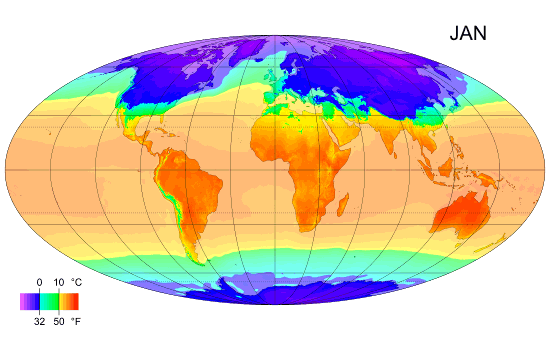
English: Animated global map of monthly long term mean surface air temperature (Mollweide projection). |
| Date | February 2009 |
| Source | Own work by uploader, sources: CRU CL 2.0 (New, M., Lister, D., Hulme, M. and Makin, I., 2002: A high-resolution data set of surface climate over global land areas. Climate Research 21: 1–25), NCEP/NCAR Reanalysis Derived data v. 1 provided by the NOAA/OAR/ESRL PSD, Boulder, CO (Kalnay et al., 1996: The NCEP/NCAR 40-Year Reanalysis Project. Bulletin of the American Meteorological Society 77 (3): 437–471.), World Coast Line. |
| Author | PZmaps |
| Other versions | Derivative works of this file: MonthlyMeanT DEC.jpg |
Licensing[edit]
I, the copyright holder of this work, hereby publish it under the following licenses:
|
This file is licensed under the Creative Commons Attribution-Share Alike 3.0 Unported license. | |
|

|
Permission is granted to copy, distribute and/or modify this document under the terms of the GNU Free Documentation License, Version 1.2 or any later version published by the Free Software Foundation; with no Invariant Sections, no Front-Cover Texts, and no Back-Cover Texts. A copy of the license is included in the section entitled GNU Free Documentation License. |
You may select the license of your choice.
File history
Click on a date/time to view the file as it appeared at that time.
| Date/Time | Thumbnail | Dimensions | User | Comment | |
|---|---|---|---|---|---|
| current | 12:38, 25 February 2009 | | 550 × 340 (405 KB) | PZmaps (talk | contribs) | {{Information |Description={{en|1=Global animated map of monthly long term mean surface air temperature (Mollweide projection).}} |Source=Own work by uploader, sources: [http://www.cru.uea.ac.uk/cru/data/hrg.htm CRU CL 2.0] (New, M., Lister, D., Hulme, M. |
You cannot overwrite this file.
File usage on Commons
The following 2 pages use this file:
File usage on other wikis
The following other wikis use this file:
- Usage on am.wikipedia.org
- Usage on ar.wikipedia.org
- Usage on ast.wikipedia.org
- Usage on azb.wikipedia.org
- Usage on az.wikipedia.org
- Usage on ba.wikipedia.org
- Usage on bg.wikipedia.org
- Usage on bo.wikipedia.org
- Usage on ca.wikipedia.org
- Usage on ceb.wikipedia.org
- Usage on ce.wikipedia.org
- Usage on ckb.wikipedia.org
- Usage on cy.wikipedia.org
- Usage on de.wikipedia.org
- Usage on en.wikipedia.org
- Usage on en.wikibooks.org
- Usage on en.wikiversity.org
- Usage on es.wikipedia.org
- Usage on es.wikinews.org
- Usage on fi.wikipedia.org
- Usage on hu.wikipedia.org
- Usage on hy.wikipedia.org
View more global usage of this file.